Historical Northeast Philadelphia
Stories and Memories ~1994
The Friends of Pennypack Park sponsored
this project.
The history was written by Harvey R. Cantor, Vice
President and official historian
Photos courtesy of Archives, City of
Philadelphia.
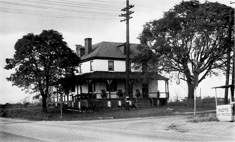
Wheatsheaf Tavern, Bustleton and Cottman Avenue in 1960.
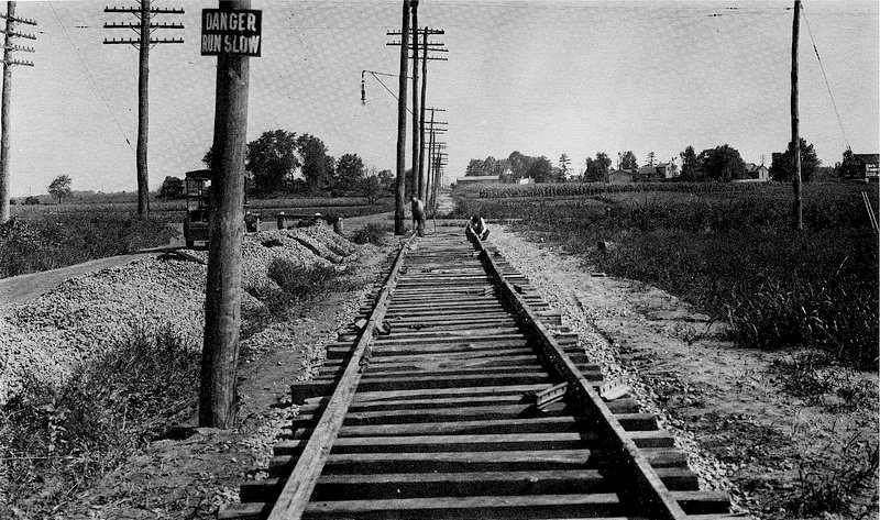
Construction of the Bustleton Trolley Line on Castor Avenue ast Rhawn Street in 1919 with Bell's Corner in the distance.
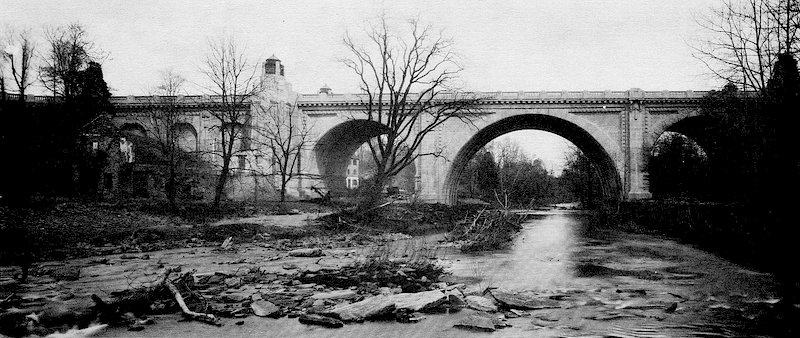
South view of Bustleton Avenue Bridge over the Pennypack Creek south of Maternity Blessed Virgin Mary Roam Catholic Church on December 8, 1903. Ruins of the La Grange Print Works to the left.
Workers Village at Pennypack Print Works with Rhawn Street Bridge in 1901. Current site of Rhawn Street Parking Lot in Pennypack Park known as "Little City".
The Pennypack Print Works ruins, with the old wooden Rhawn Street Bridge in 1900.
The 1893 widening of the "King's Highway Bridge" (Frankford Avenue). Built in 1697, it is the oldest stone arch bridge in America. Still used to carry a major highway. Designated a National Civil Engineering Landmark.
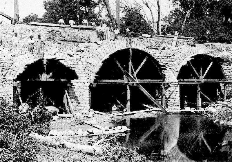
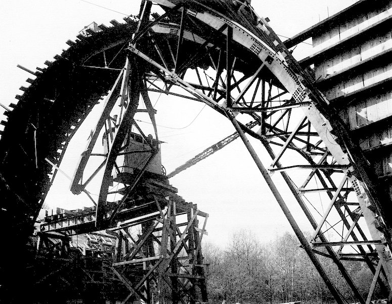
Construction Photo of "Bensalem Bridge" over Pennypack Creek. Ruins of the Old Axe Factory Bridge at bottom. Taken October, 1917.
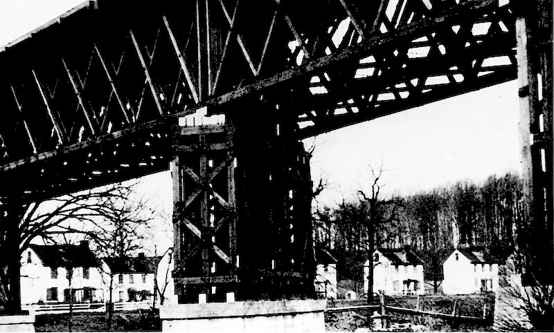
The Bensalem Bridge carrying Roosevelt Boulevard over Pennypack Creek looking east. Ruins of Carpet Mill left foreground. Taken April 19, 1920.
Tenant Farm atop the Pennypack Creek at Krewstown Road, November, 1949.
Pine Road Bridge over the Pennypack Creek. Built in 1900. This was the first concrete cast bridge in America. It stood until 1976 when the present bridge was built.
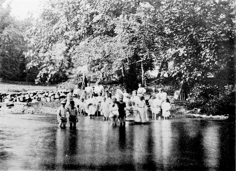
A summers day at one of the "Ole Swimming Holes" that were popular along the Pennypack Creek. |
Pennypack Park includes 1,600 lush acres of land from the Delaware River to the Montgomery County Line at Fox Chase Farm. The Park is approximately 8 miles in length and at the maximum width of one mile between the Krewstown and Verree Road areas. The creek itself begins near Maple Glen and flows to the Delaware about 24 miles in distance, fed by several tributaries within the park. Wooden Bridge Run, Sandy Run, Paul’s Run, and Mallard Creek each create park land radiating from the main body of the park. Gone are the mills, the factories, and factory villages of Lower Dublin and Delaware townships. Villages such as those at the Pennypack Print Works, La Grange on the Somerton-Bustleton Pike, and Verreeville are but a ghost of their former selves with a few remaining physical signs. However, the old towns of Holmesburg, J3ustleton and Fox Chase are evidence of the importance of these mills in creating communities. The name Pennypack, it is said, is derived from the Lenni Lenape word meaning, “deep dead water, water without much current.” Before William Penn, the Swedish settlers called the area by many variations of that name. However, on Surveyor General Thomas Holme’s plan of the Philadelphia area in 1681, it is called Dublin Creek, and on a later map it is called Dublin River. In 1701, Penn refers to the area from the old name “Pemmapecka.” The Swedes preceded Penn and his Quakers. Penn did not disturb these holdings. On Holme’s map you will find the names Peter Rambo, Nel Nelson, and Erick Meels; all of whom had land at the mouth of the creek at the Delaware. Penn received title of the land between Pennypack and Neshaminy Creeks on June 23, 1683 from Chiefs Tammany and Metamequan of the Lenni Lenape. Well Spring. A large portion of Pennypack Park was part of Well Spring, the plantation of Thomas Holme, consisting of 1,646 acres. The deed dates back to September 8, 1682. HoLme would transfer it to his daughter, Eleanor, who deeded it back to him after marrying William Penn’s cousin, Silas Crispin. In 1688, Holine moved from his home at Front and Arch Streets to Well Spring and died there in 1695. At the time, the nearest thoroughfare to Holme’s pantation was known as Susquehanna Road (now Welsh Road). The land remained in the family until 1864. The Pennypack Mill. Built in 1697, on 16 acres of land sold from Holine’s Estate to Charles Saunders, the Pennypack Mill was built with stone from the nearby quarries. Farmers came great distances from the west of Holmesburg on Welsh Road to acquire needed supplies from the mill. New Jersey farmers often rowed across the river and then 1 1/4 miles up the creek to the mill. Pennypack Bridge-Kings Highway. The bridge was erected in 1697 and is the oldest stone arch bridge in continous use in the United States. The road it carries over the Pennypack has changed from a path to a toll road to a modem city street. The name changed from King’s Path, to King’s Highway, to Bristol Turnpike, to Frankford Road, to Frankford Avenue (US #13). Prior to the construction of Roosevelt Boulevard (U.S. #1) in the 1920s, the road was the main route from Philadelphia to Trenton, New York, and points north. Over the bridge have come the Lenni-Lenape, the Continental Army, members of the first Continental Congress, farmers on their way to the Mills along the Pennypack, and the common traveler. The Massachusetts delegation, including John Adams, dined at the Red Lion Inn at the Poquessing, on August 29, 1773 and then crossed the bridge on their way to Philadelphia. Washington passed over the bridge and stayed at the Inn at the south side of the bridge which later became the Washington Inn during the Revolution. He passed over the bridge ceremoniously on April 30, 1789 on the way to New York, for his first Inauguration. The Pennypack Bridge became the center of controversy as the road became burdened with more and more traffic. On March 24, 1803, the Frankford and Bristol Turnpike Company was formed. The old road became a macadam road. A toll house was placed at the south end of the bridge, north of the Mill Race. The toll gate was in operation until July 1, 1892 when that portion of the turnpike was sold to the City of Philadelphia. The first trolley went into service over the bridge from Cedar Hill (Frankford Avenue and Bridge Street) to the Poquessing in 1895. To accommodate the increased traffic the bridge was widened and heightened in the late 1890s and early 1900s, but it kept the original style. In 1928 there was a call to demolish the bridge and replace it with a wider one was quelled. The bridge still stands today. Rowland Shovel Work. The original business, dating back to 1826, was founded by Jonathan Rowland. Rowland was a descendent of John Rowland, who arrived from England with Penn on his ship The Welcome. The shovel work was named the Maxwell Rowland & Co. after Jonathan’s youngest son and employed six to eight men. In later years, the business was run by Maxwell’s sons, nephews and grandson. Maxwell became head of the firm in 1854. He died in 1882 at the age of 60, and was buried in Cedar Hill Cemetery in Frankford. When Maxwell Rowland died his son, William, took over the business. Maxwell Rowland was praised for his civic activity. He was a member of the City of Philadelphia’s Select Council from 1875 to 1878. He and his son William both were Directors and Treasurers of the Holmesburg and Bustleton Railroad. Rowland Station was on a hill above the Rowland Shovel Works. Rowland’s other son, Jonathan, was a civil engineer and was Vice-President and manager of the Morris, Tasker & Co. Steel Works. Rowland also helped found the Holmesburg Waterworks. In an expansion in 1852, Rowland bought land on the north side of the creek at Wooden Bridge Run from Samuel Willits who ran a linseed oil plant. The site was originally a saw mill. Water power was obtained from another mill structure on the site right on Wooden Bridge Run, which once was the site of a powder mill and later a dye works. Philadelphia Hardware was known all over the country. It helped “win the West.” There were four factories along the Pennypack producing axes, shovels, rakes, and picks. The Rowland Shovel Works was an exhibitor at the Great Centennial of 1876 in Fairmount Park. The Company won a first prize award for their long rectangular shovel. A fire in 1884 nearly ended the life of the company, but the plant was rebuilt. Crystal Palace. This stately house was built in 1855 by James Pierson, was used as a hotel and summer boarding house. The land was the main part of “Well Spring,” a 57-acre parcel that eventually was sub-divided eventually by the Crispin family. The land extended along the Pennypack from Welsh Road to “Crystal Springs.” South of Rhawn Street was a farm of 80 acres, reaching from the creek to Bristol Turnpike (Frankford Avenue), known as Foxdale, owned by George Fox. In 1864 James Pierson, who had married a Crispin purchased the house he had built. “Foxdale Grove”, a picnic ground near the spring, was run jointly by two prominent townspeople, Crispin and Fox. A popular spot for Tacony and Holmesburg residents, Foxdale Grove was featured in the United States Gazette around July 4, 1843. Pennypack Print Works. Erected by Samuel Comly in 1830, the Print Works was the site of an old saw mill and corn mill. The works was owned by Andreas Hartel, Joseph Ripka and John William in 1852. William left later to operate the La Grange Print Works in 1864. Oxford and Lower Dublin Poor House. The House was established around 1820. The farm ran along the creek from Sandy Run to the east for a third of a mile to the western boundary of Well Spring. Lincoln High School is now on this site. Bellevue. Bellevue, the Peninsula forming the “U” shaped curve in Pennypack creek was part of the Crispin Estate. In 1792 Benjamin Crispin was born at Bellevue. He went on to be a prominent member of the State Legislature and State Senate. Crispin was elected Speaker in 1843. He was this area’s first member of Common Council at the time of the City’s Consolidation in 1854. His house was built in 1828. Echo Hill. This property was owned by two men, (Outerbridge and Harvey), from Bermuda. They built two mansions — the upper one, “Echo Villa” and the lower one, “Lochside”. The Pennypack Riding Club later used the estate as its headquarters. Evergreen Terrace. This was a majestic estate with entrances on Newton Road and another on Welsh Road. On the southern end of the property towards the creek stood a cottage and farmhouse. On the creek was the yarn mill, originally an axe factory, that was owned by George Rodgers. The Otto farm lies east of the dam overlooking the creek. La Grange. On May 20,1684, William Penn granted 500 acres to Allen Forester. The parcel was sub-divided and in 1696 fifty-seven (57) acres were passed on to Richard Mason. Mason died in 1714. His wife remarried and her new husband, John Aikins, built a grist mill, with two pairs of mill stones. In 1767, the mill was owned by the Snyder family. At the time, the property extended to the north to the turnpike. In 1790 more land was bought and the mill grounds stretched to Chestnut Lane. Originally, the Bustleton Somerton Pike followed the current Newtown Road which ran over the old Newtown Bridge near Newtown and Winchester Road. That bridge still stands. The stone bridge over the creek, on the second route, was built in 1805 replacing a wooden one. This bridge stood until the mid-1960s when Bustleton Avenue was re-routed. In 1807, the mill was sold to Andrew Baum, who operated a lead pencil factory there. It failed and in 1811 he sold the property to the Gordon Brothers who operated a woolen mill which also failed in 1821. During the 1820s the mill reverted back to a pencil factory. The mill finally found success and stability in 1830, when Hubbs and Brown, the new owners, formed the La Grange Company for the manufacture of art supplies, calico and silk. Hubbs and Brown hatched a wild fad in the area of raising silkworms. Buildings were erected in Byberry Township to raise worms and hundreds of mulberry trees were imported. Printers were brought from England. The business was extremely successful. In 1840 the Works, then owned by the Wendall & Perkins Co., printed large handker- chiefs for the Presidential campaign of William Henry Harrison, noting him as the hero of the Battle of Tippecanoe. On the north side of the creek on the east side of the road, land was purchased to build houses for the mill workers. This was known has “Vinegar Hill”, as one woman sold vinegar out of her cellar. In 1844 a row of frame houses was erected on the west side of the road. In 1842, the mill and the print works were among the largest in the United States when a mysterious fire broke out. A second large dye and print works was built soon after. The mill and print works failed in 1850. On the north part of the property stood a mansion where the poet, John Greenleaf Whittier, lived from 1835-36. The mill lay idle after a fire in 1865. Then in 1874 John Willian converted the mill into a dye works. He donated land to build the Maternity B.V. M. Church. He died in 1880. The land was vacant and was sold to the city for the Pennypack Parkway, which was not built. The origin of Pennypack Valley as a park. As a park, Pennypack came into being on March 20, 1905 with an ordinance in both Common and Select Council Chambers of Philadelphia. The ordinance set forth the planning and acquisition that developed into the 1600 acre park we know today. Over the next sixty years, well over 150 properties were incorporated into the park, including the Crispin Cemetery where Thomas Holme is buried. The park has grown to the size of 20% of the total Fairmount Park system. It is larger than Central Park in New York, as well as most of the parks in any major US city. The Northeastern, Torresdale, Bensalem or Roosevelt Boulevard. As planned in a 1903 ordinance, a 12 mile, 300 ft. wide boulevard would begin at Broad Street and Cayuga and would follow its current route until it reached the circle at Holme Avenue and Solly Avenue. It would turn northeast on what is now Poquessing Avenue and continue past the intersection of Blue Grass and Willits Roads to Academy and Grant Avenue. It then would follow what is now Grant Avenue to the Delaware River. The main entrances would be at Frankford Ave. or Bristol Pike, at Welsh Road. On the north of Pennypack Circle several large avenues would radiate to Torresdale, Holmesburg, Bustleton and Fox Chase. Later, however, the route of the Boulevard was changed to comply with and to provide a main route of the new Lincoln Highway to New York. The major engineering accomplishment along the route was the completion of the Bensalem Bridge in 1919 by Day & Zimmerman, the builders of the bridge, who are a thriving engineering firm in Center City today. The Great Depression and Pennypack Park: The major development of the Park that we have today was as of the result of the programs that were created to end the Great Depression. First, under the New Deal’s Civil Works Administration during the 1933 and 1934 the bridle paths from Axe Factory Road, at Roosevelt Boulevard to Susquehanna Road were built resulting in twenty miles of bridle paths and foot paths, which included the building of 12 bridges on those paths. The C.W.A. was followed by the Works Progress Administration. In November 1935 in his election for Mayor, S. Davis Wilson, Republican, declared that the New Deal progams must be “utterly repudiated.” However, soon as he was in office he did all he could do to get programs funded by the W.P.A.. The City’s legacy of the W.P.A. is astounding. There was construction at the Zoo, the creation of League Island (Roosevelt) Park, the airport and the construction of over 900 buildings within the city by the W.P.A.. Over 40,000 were employed at W.P.A. jobs in Philadelphia at one time. In Pennypack Park, the W.P.A. rebuilt the dams and constructed buildings that created popular swimming areas along the creek at Verree Road, Roosevelt Boulevard and Frankford Avenue. These “Ole Swimming Holes” made the Pennypack famous. Picnic groves were built in several places. A trail six miles long was built on the south side of the creek from the Verree Road to Welsh Road. The Fairmont Park Commission’s Pennypack Tree Nursery, near the Roosevelt Boulevard was active with W.P.A. Over 100 workers planted trees from there in all the parks of the Fairmount Park Commission. The W.P.A. Writers Project was responsible for writing of the W.P.A. Guide to Philadelphia. In that guide, which showcased the historic area in around Philadelphia, were two tours of Pennypack Park was included. “Along the Pennypack by the Ole Swimming Hole” was its title. This guide was reprinted several years ago on the fiftieth anniversary of its publishing. The Pennypack Park helped to briefly ease the dismal times for the children of the depression. The Pennypack Park Day Camp was in operation from 1937 until 1940 with 4,000 children enjoying Pennypack Park in July and August during those years. It was located at the Pine Road section of the Park, and was run by the Park Commision, with help of the Board of Education, and the W.P.A., the National Youth Administration and the Federal Music Project. The children came from the W.P.A. sponsered programs through out the inter-city to the camp. There were games, group singing, amateur programs, hikes, swimming and fishing. Other activities included an assembly, with singing contests and an amateur talent program. Lunch was a benefit of attending the camp, for many of the children were malnourished. There are stories of some of the children saving some their lunch to take home. Interviews... The interviews were done by Ms. Miriam Barsky’s Mentally Gifted 5th grade class at the Robert Pollack Elementary School.
Interview with Edward White, age 68 by Andrew DeMarco, age 10 Edward White has lived in Northeast Philadelphia for over thirty-two years. Mr. White describes the area as looking like farmland, open and wide. Everything seemed like it was less. Less people, less houses, less stores, less cars, less products, less violence, and less air traffic. For recreation Mr. White always liked to swim, play cards, go to amusement parks and be with friends. When television was invented that became a big form of entertainment. Mr. White remembers his favorite amusement park that had a huge ferris wheel and games of chance (betting). He also remembers a dance hall where everyone would meet on weekends. Mr. White remembers that where Beth Tefilah (a synagogue) is now, a lady used to raise chickens and roosters even though it was against the law. Where the Atrium Apartments are now a man used to raise horses. Mr. White remembers when there were only five houses along the whole Welsh Road across from Pollock School. Things look so different now.
Interview with Betty Lyons, age 65 by Mindy Lyons, age 10 Betty Lyons has lived in this area of Northeast Philadelphia since 1956. She has seen many changes in the thirty seven years that she has lived here. She describes her early years here as “O.K.”, she says that things were different. She did a lot of shopping at Sears Department Store on the Boulevard and now that important store is gone. She shopped at a Food Fair that was like our supermarkets but much smaller. Betty Lyons misses two important things from the past. She misses all the beautiful open spaces and she misses not being able to leave her home unlocked. I guess she misses trusting people and seeing nature. She says that people stayed in their own communities more and traveled less. When you did travel, trolleys and public transportation were frequently used. Betty Lyons likes movies as a form of recreation now. When she first lived in this area she listened to radio and just stared watching televisions. Videos had not been invented. Typewriters were even manual. Getting dressed up for special occasions was fun. Ladies wore hats and fancy gloves. Some clothes took a lot of work for women to care for. Now ladies wear more sportsclothes and don’t fuss so much.
Interview with Earlene Stout by Thomas Taggart, age 10 Earlene Stout’s dad, Earl Stout was an union leader. When I interviewed Earlene Stout I learned that Mr. Stout built the house on Welsh Road, between the 7-Eleven and the real estate office. That special house was recently knocked down. I tried to imagine how wonderful it would be to build your own home, carrying the wood, designing it and knowing that it was yours. Mr. Stout must have been a remarkable craftsman. It’s sad that it was necessary to destroy it.
Interview with Edith Bernstein, age 60+ by Bryan Bernstein, age 10 Mrs. Bernstein remembers that 30 years ago her family would drive from Oxford Circle to Cottage Green for an outing. When her family made this trip she felt she was going into the wilds of the countryside. Trees were everywhere and small farms dotted the landscape. Mrs. Bernstein moved to Ashton Road in the 1970s and when she bought her home it was the last house in the development. Everything behind her was either open land or wooded lots. Slowly and gradually the scene began to fill with houses, stores and roads. With the growth and development has come traffic, noise and pollution. Conveniences are paid for with inconveniences.
Interview with Mrs. Kinniburth, age 70+ by Jesse Kowal, age 10 Mrs. Kinniburth has lived in this area over twenty years and has seen many many changes. When she first bought her home she could look out and see land everywhere. That has really changed. People have much less land now and that means less work and responsibility but also less pleasure from nature. Mrs. Kinniburth is not happy about the increase in violence and crime in the streets. People used to be able to trust each other more and help came from strangers and friends alike. Violence has made public facilities less helpful for her and other seniors. Public transportation does not seem as good and people seem less willing to support others in the community. Mrs. Kinniburth does not remember things she did for leisure. Her early years in this community seem to have been filled with work and responsibility. Housework was actually sometimes thought of as recreation. Keeping a home and family organized and happy was reason enough for everything. Mrs. Kinniburth’s children went to school at Nazareth Academy and St. Catherine's. She remembers her early years in this community as being hard and busy. |